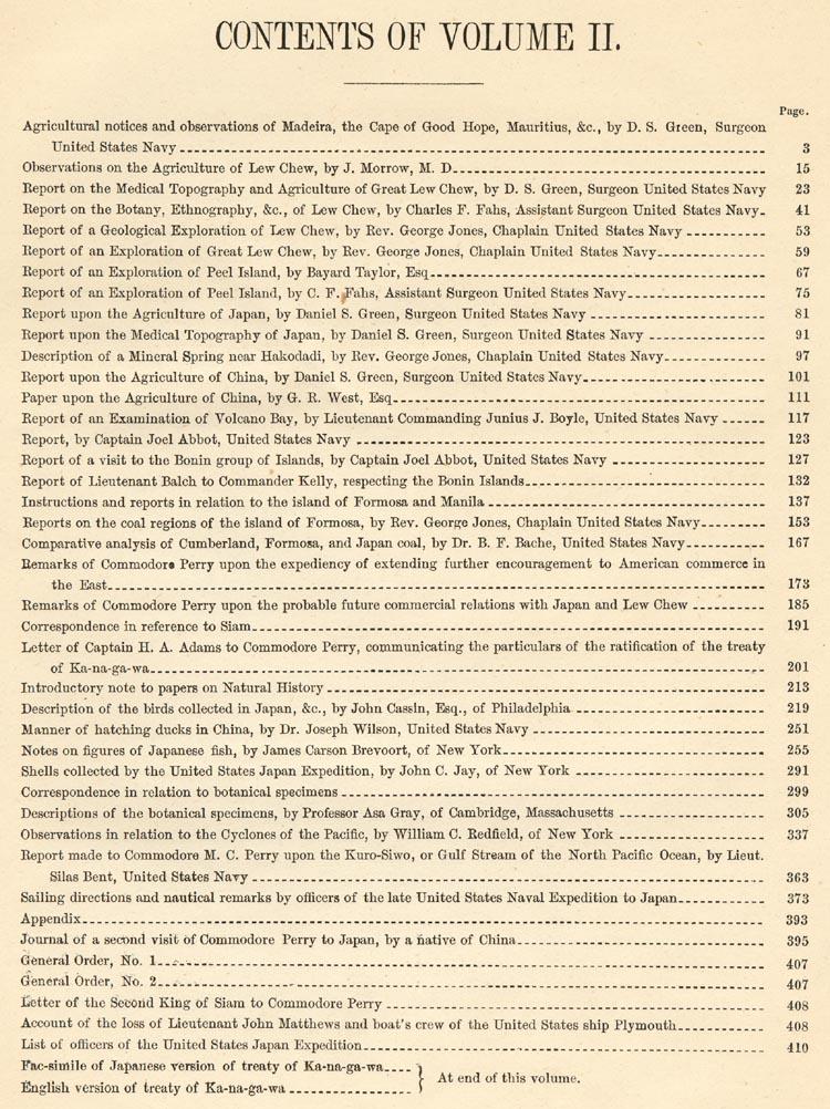
|
Narrative of the Perry Expedition to Japan |
|
The Perry Expedition: General Information : Related Books/Pubs The Lithographs: Characteristics : Condition : Listing : Buying Order On-line: Lithograph Price List : Book Price List ABE Book List: BaxleyBooks Inventory on ABE Special Interest Books/Art: ~ K. Ogawa - Color Collotypes and Books/Prints ~ T. Hasegawa - Color Woodblock Books ~ Shimbi Shoin - Art Reproduction Books ~ Tamamura/Takagi, Kobe - Color Collotype Books ~ Georges Bigot - Etchings & Art ~ Keisuke Serizawa - Calendar Folios & Art ~ Woodblock Printing - Process & Miscellaneous Books ~ Japanese Woodblock Prints ~ Blackie the Photographer - Okinawa Photo Essay Books Meiji Era - Japan Views & Images (Price Lists & Information): ~ Albumen Photos : Chromolithographs ~ Colored Albumen Photographs (from Brinkley Books) ~ Stereoviews : Kazumasa Ogawa Collotypes ~ CDV - K. Ogawa : CDV - Other : Cabinet Cards ~ Glass Slides, "Magic Lantern" - Hand Colored ~ Fujiya Hotel, Miyanoshita PayPal Accepted: Pay for Purchases with PayPal Buying Books: Our Book Buying Interests BaxleyStamps: Main Page : Ryukyu Stamps : Japan Stamps Copyright and Fair Use Policy is here.
|
This volume (414 numbered pages) is made up of a series of reports, most by expedition members on the topography, geology, botany, agriculture, and resources of the countries visited. It also contains military orders and correspondence of Commander Perry. Unlike Volume I, which has a total of 89 (90) lithographic plates - most tinted, this volume has a wide variety of plate types. There are uncolored engraved plates (4), handcolored engraved plates (13), tinted lithographs (4) and handcolored lithographs (6). This comes to a total of 27 diverse type full page plates. The following art/illustrations and maps are in this volume:
Many of the below Reports/Documents (including plates) have been extracted from Volume 2 and are available (with accompanying plates). To see this price list, click here.
(The titles are those shown on the actual report and may vary slightly from the wording in the Table of Contents for Volume 2).
The Agricultural of Madeira, the Cape of Good Hope, Mauritius, etc, by D.S. Green Surgeon, MD, Surgeon, United States Navy, pages 1~12.
The Agriculture of Lew Chew by J. Morrow, M.D., pages 15~20.
Medical Topography and Agriculture of The Island of Great Lew Chew, by D.S Green, Surgeon United States Navy, pages 21~38.
The Botany, Ethnograph, etc, of the Island of Great Lew Chew, By Chas. F. Fahs, Assistant Surgeon United States Navy, pages 39~50.
Geological Exploration, etc., of the Island of Great Lew Chew, by Rev. George Jones, M.A., Chaplin USN, pages 51~56.
Text Illustrations:
Drawing of Shaw Bay (4 different views)
Drawings of Abbey Point (2 different Views)
An Exploration of Great Lew Chew, by Rev. George Jones, M.A., Chaplin, USN, pages 57~64.
The Exploration of Peel Island, by Bayard Taylor, Esq, pages 65~72.
An Exploration of Peel Island by Chas. F. Fahs, Assistant Surgeon USN, pages 73~78.
The Agriculture of Japan, by Daniel S. Green, M.D, Surgeon USN, pages 79~88.
Medical Topography of Japan, by Daniel S. Green, Surgeon USN, pages 89~94.
A Mineral Spring Near Hakodadi, by Rev. George Jones, M.A, Chaplin USN, pages 95~98.
Text Illustration:The Agriculture of China, by Daniel S. Green, Surgeon, USN, pages 99~108.
Drawing "Mineral Spring Near Hakodadi"
Paper Upon the Agriculture of China, by G.R. West, pages 109~114.
Tinted Lithographic Plates - 4 plates
- Various Chinese Implements
- Chinese Irrigating Machine Worked by a Buffalo
- Chinese Irrigating Machine Worked by Man
- Chinese Apparatus for Hulling and Course Grinding Rice
An Examination of Volcano Bay, Island of Jesso, by Lieut Comd'g Junius J. Boyle, pages 115~120
Observations and Soundings of the Islands of Japan, from Hakodadi to Simoda, by Captain Joel Abbot, USN, pages 121~124.
Examination of the Bonin Group, by Captain Joel Abbott, USN, includes a report of Lieutenant Balch to Commander Kelly, respecting the Bonin Islands, pages 125~133.
Instructions and Reports in Relation to a Visit to Manila and Formosa, pages 135~150.
Visit to the Coal Regions of the Island of Formosa, by George Jones, M.A., Chaplain, USN, pages 151~164.
Map & Text Illustrations (3):
Map of Coal Mines of Formosa (full page)
Drawings of Geological Features (3 different drawings)
For more information on the above three reports pertaining to Formosa, click here.
Remarks of Commodore Perry on the Expediency of the Extendion of Further Encouragement to American Commerce in the East, pages 171~182.
Remarks of Commodore Perry upon the Probable Future Commercial Relations with Japan and Lew Chew, pages 183~188.
Correspondence in Reference to Siam, pages 189~198.
Letter of Capain H.A. Adams to Commodore Perry, Communicating the Particulars of the Ratification of the Treaty of Ka-na-ga-wa, pages 199~210.
Papers on Natural History (title page only), page 211.
Engraved Plates, black and white, of Animals - 2 plates
- Yack
- Japanese Fox
Introductory Note to Papers on Natural History, pages 213~4.
Birds, by John Cassin, pages 215~248.
A.--Birds Collected in Japan, pages 219~235.
B.-- Birds Collected in China, the Loo Choo Islands, the Islands of Singapore and Ceylon and on the Coast of California, pages 236~248.
Lithographs, handcolored, of Birds - 6 plates
Text Illustrations:
Drawings (2) of duck hatching materials
Notes on Some Figures of Japanese Fish Taken From Recent Specimens by the Artists of the U.S. Japan Expedition, by James Carson Brevoort, pages 253~288.
Steel Engravings, handcolored, of Fish/Eels - 10 plates. Plates are placed after page 256.
Shells Collected by the Japan Expedition Together With a List of Japan Shells, by John C. Jay, of New York, pages 289~298.
Steel Engravings, handcolored (2) - B/W (3), of Shells - 5 plates. Plates placed after page 298 in sequence.
Correspondence (in relation to botanical specimens), 299~302.
Account of the Botanical Specimens, prepared by Professor A. Gray, Assisted by Mr. Sullivant, Dr Harvey, etc., pages 302~332.
Observations in Relation to Cyclones of the Western Pacific, by William C. Redfield, pages 333~360.
Text Illustrations showing:
1. Track of Cyclone in China Sea in 1831 (at page 344).
2. "Mississippi," October 7, 1854 (in a cyclone) (at page 347).Full Page Chart (three folds out):
"Gales and Huricanes" (after page 354).
Report Made to Commodore M.C. Perry Upom the Kuro-Siwo, or Gulf Stream of the North Pacific Ocean, by Lieut. Silas Bent, pages 361~370.
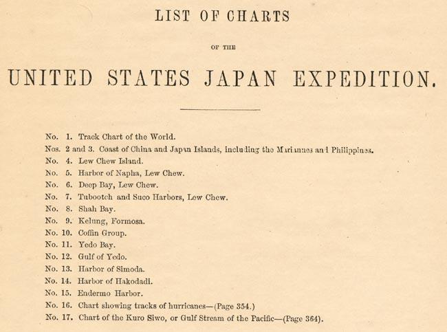
Charts/Plates (17):
1. Kuro-Siwo and Gulf Stream Chart(three folds out - after page 364).
2~17. Sailing charts of track, winds, currents, barometer and temperature for several sailings (16 Plates, Plate I to XVI - after page 370.
Sailing Directions and Nautical Remarks by Officers of the Late United States Naval Expedition to Japan (compiled by Lieut. W.M. Maucy), pages 371~392
Appendix.
Journal of the Second Visit of Commodore Perry to Japan, by a Native of China (Wells Williams), pages 393~406.General Order, No. 1 (requires notes and drawings be given to Captain of Fleet), page 407.
General Order, No. 2 (requires all Officers to devote spare time to gathering information), at pages 407~408.
Letter from the Second King of Siam to Commodore Perry (dated July 16, 1856), at page 408
Account of the loss of Lieutenant John Matthews and boat's crew of the United States ship Plymouth, at pages 408~409.
List of officers of the United States Japan Expedition, at pages 410~414.
Fac-simile the Original Treaty with Japan (Japanese Version of the Treaty of Ka-na-ga-wa), pages 415-418 and 1-14. [The treaty is presented in Japanese format - reading right the right page to left page (ie back to front). Therefore the first page of the fascimile in the volume is numbered 14 and the numbers decrease as you go from left to right (ie front to back)].
"Japanese Treaty" English version of the treaty of Ka-na-ga-wa (2 unnumbered pages).
Index
List of Charts of the United Stated Japan Expedition.
Lithographs - Tinted  Chinese Implements/Machines
113-1	Various Chinese Implements - Plate I
113-2	Chinese Irrigating Machine Worked
	by a Buffalo - Plate II
113-3	Chinese Irrigating Machine Worked
	by Men - Plate III
113-4	Chinese Apparatus for Grinding Beans,
	Bones and other Substances - Plate IV


Engravings - Animals (Natural History)
210-5	Yack - Plate I (Engraving)
210-6	Japanese Fox - Plate II (Engraving)


Lithographs, Handcolored - Birds
222	Phasianus Versicolor Viellot (Lithograph - Hand colored)
224	Phasianus Soemmeringii (Lithograph - Hand colored)
228	Numenius Tahiticus (Lithograph - Hand colored)
236	Garrulax Perspicillatus (Lithograph - Hand colored)
238	Herterornis Sericea (Lithograph - Hand colored)
240	Ixos Haemorrhous (Lithograph - Hand colored)


Steel Engravings, Handcolored - Fish, 10 plates, total of 29 fish/eels
256-1	Serranus Tsirimenara, etc. (2 fish) - Plate III
256-2	Sebastes Marmoraeus, etc - (2 fish) - Plate IV
256-3	Pelor Japonicum, etc. (3 fish) - Plate V
256-4 	Etroplus Fumosus, etc. (6 fish) - Plate VI
256-5	Scomberescox, etc. (4 fish) - Plate VII
256-6	Serranus Urodelus, etc. (3 fish) - Plate VIII
256-7	Salmo PerryI, etc. (2 fish) - Plate IX
256-8	Salmo---?, etc. (3 fish) - Plate X
256-9	Muraena Kidako, etc. (2 eels) - Plate XI
256-10	Triakis, etc. (2 fish) - Plate XII


Engraved Plates, five plates showing a total of 44 Shells
      2 handcolored and 3 black and white
297-1	10 shells - Plate I
297-2	10 shells - Plate II (hand colored)
297-3	4 shells - Plate III
297-4	2 shells - Plate IV
297-5	17 shells - Plate V (hand colored)

Maps - main body of volume
155	Coal mines of Formosa (single page engraving)
354	Gales and Hurricanes (fold out map)
364	Kuro-siwo - equivalent to Gulf Stream - (fold out map)

Maps - rear of book in map portfolio
Below 15 more after Index

Charts - main body of volume
370	Track, winds, currents, barometer and temprature
	 charts for several sailings (16 Plates)


10 Wood-cuts:

54	Coal bluff, Shah Bay (view 1) - Lew Chew
55	Limestone formation (view 2) - Lew Chew
55	Limestone formation at Abbey Point (view 3) - Lew Chew
56	Limestone formation at Abbey Point (view 4) - Lew Chew
98	Mineral spring near Hakodadi
156	Kelung harbor - islands seen approaching, seen from the
	 nortward (very small 6.7x 2.2mm)
158	Sandstone formation - Formosa
159	Coal mines - Formosa
344	Cyclone track map
347	"Mississippi," October 7, 1854 - in typhoon


Fac-simile of Treaty

414	Fac-Simile of the Treaty with Japan
	 Japanese language version (14 pages)


Maps/Charts

--Map Folio at Back of Volume--

No. 1.     Track Chart of the World.
No. 2 & 3. Coast of China and Japan Islands,
             Including the Mariannes and Philippines.
No. 4.     Lew Chew Island [Okinawa].
No. 5.     Harbor of Napha, Lew Chew [Naha Harbor].
No. 6.     Deep Bay, Lew Chew [Nago Bay].
No. 7.     Tubootch and Suco Harbors, Lew Chew [Toguchi & Sesoko-jima Harbors ].
No. 8.     Shah Bay, Lew Chew [Shioya Bay].
No. 9.     Keelung Harbor, Formosa.
No. 10.    Coffin Group.
No. 11.    Gulf and Bay of Yedo.
No. 12.    Gulf of Yedo.
No. 13.    Harbor of Simoda.
No. 14.    Harbor of Hakodadi.
No. 15.    Endermo Harbor.

--Merged into Text--

No. 16.    Chart showing tracks of hurricanes
	     --(page 354) (3 folds out).
No. 17.    Chart of Kuro Siwo, or Gulf Stream of the Pacific
             --(Page 364) (3 folds out).
There is a List of Charts after the index in Volume 2. The above listing of maps No. 1 to No. 15 is from that source. The maps/charts listed as No. 1 through No. 15 are bound in a map folio at the back of the volume. When you count the maps at the back there will be 14 (not 15) distinct items as No. 2 and No. 3 are on the same sheet. They are bulky and often have tears and misfolds. They are separated from the body of the book by a stub, composed of numerous sheets of paper, that is approximately 3/4+ in wide and 1/4 in thick. The first map (No. 1, above) is huge. It has 4 folds out and 1 complete fold down. It is over 3 ft wide by 2 ft high when fully opened. The map invariably has tears from opening. The next map (No. 2, above) is even larger. I recommend a course in map folding before you tackle it. It takes patience to properly open and fold these maps and, unfortunately, that seems to be lacking with most of the owners of this book. In addition, since these maps are at the back of the book and bulky they tended to be exposed to the environment more and thus have more foxing and toning than the rest of the book. It is normal for the folded edges to be toned, stained and worn.
|
If you have material to sell, please visit this page: Buying.
George C. Baxley
Perry Expedition to Japan Books & Lithographs |