Map of The Luchu Island with
Insert of Okinawa or Great Luchu
From an Article Entitled:
The Luchu Islands and Their Inhabitants

by Basil Hall Chamberlain


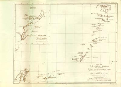
Click the Map for Larger Picture

 
This map is extracted from the 1895 Geographical Journal article that is discussed below.

 
Chamberlain, Basil Hall:
The Luchu Islands and Their Inhabitants, a three part extracted article from The Geographical Journals of 1895. The three parts are:

  • April, 1895, Volume 5, No. 4 (pages 289 - 319),

  • May, 1895, Volume 5, No. 5 (pages 446 - 462) and

  • June, 1895, Volume 5, No. 6 (pages 534 - 545).
In all these three parts, there are a total of 57 pages, 1 fold out map of the Luchu Islands, 4 photographs, 5 illustrations. The map page size is approximately 34 x 25 cm.

This three part article is found in the hardback bound edition of Geographical Journal, Volume 5-6, 1895. The Geographical Journal is a publication of The Royal Geographical Society, London. The printer for the hardback volume is William Clowes and Sons, Limited, London. The bound volume for 1895 includes Volume 5 (January - June, 1895) and Volume 6 (July - December, 1895). The Map of Luchu Islands is found after page 408 of Volume 5, No. 4 (April, 1895) and is not bound in with the article that appears in that issue.


We Are Buying the 1856-7 Perry Expedition Books and Lithographs.
If you have material to sell, please visit this page:
Buying.

George C. Baxley
PO Box 807
Alamogordo, NM 88311

575.437.8707

Perry Expedition to Japan Books & Lithographs
BaxleyStamps.com  gbaxley@netmdc.com